
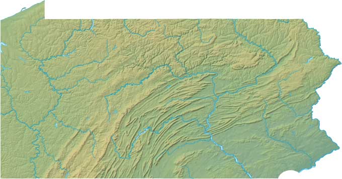
Pennsylvania Relief Map
Static Pennsylvania Relief Map
Interactive Pennsylvania Relief Maps
The interactive relief map choices include a standard Google terrain map and an enhanced Google terrain map with Street View capabilities. To zoom in or out on either of these Pennsylvania maps, click or touch its plus (+) button or its minus (-) button, respectively. To pan either map in any direction, simply swipe it or drag it in that direction. To display either of these Pennsylvania terrain maps, click or touch one of the following menu options.
Pennsylvania's highest mountain is Mount Davis, whose peak is 3,213 feet above sea level. The largest lake in Pennsylvania is Raystown Lake. If you are planning a visit to Pennsylvania, please see Visit PA, the official state tourism site, where you can find a wide range of travel and vacation information. For information about Pennsylvania history and recreational activities, visit the following National Park sites.
Pennsylvania National Parks
- Allegheny Portage Railroad National Historic Site
- Appalachian National Scenic Trail
- Chesapeake Bay Gateways Network
- Delaware & Lehigh National Heritage Corridor
- Lower Delaware National Scenic River
- Delaware Water Gap National Recreation Area
- Edgar Allan Poe National Historic Site
- Eisenhower National Historic Site
- Flight 93 National Memorial
- Fort Necessity National Battlefield
- Friendship Hill National Historic Site
- Gettysburg National Military Park
- Gloria Dei Church National Historic Site
- Hopewell Furnace National Historic Site
- Independence National Historical Park
- Johnstown Flood National Memorial
- North Country National Scenic Trail
- Potomac Heritage National Scenic Trail
- Steamtown National Historic Site
- Thaddeus Kosciuszko National Memorial
- Upper Delaware Scenic & Recreational River
Copyright © 2005-2024 State-Maps.org. All rights reserved.
Pennsylvania-Map.org is a State Maps reference source.
To facilitate browsing, certain external links will open in new windows.
Pennsylvania-Map.org is a State Maps reference source.
To facilitate browsing, certain external links will open in new windows.