
Pennsylvania Map
|
 |
 |
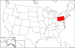
Where Is Pennsylvania?
If you look at the map to the right, you will see Pennsylvania colorized. The Commonwealth of Pennsylvania is bounded by New York on the north, and by Maryland on the south. It is bordered on the east by New Jersey, and on the west by Ohio. Pennsylvania is bounded by the State of Delaware on the southeast, by Lake Erie on the northwest, and by West Virginia on the southwest.
Pennsylvania Maps
Pennsylvania is the 32nd largest state in the United States, and its land area is 44,817 square miles (116,076 square kilometers). The state comprises sixty-seven counties. This Pennsylvania map site features road maps, topographical maps, and relief maps of Pennsylvania. The detailed, scrollable road map displays Pennsylvania counties, cities, and towns as well as Interstate, U.S., and Pennsylvania state highways. The pannable, scalable Pennsylvania street map can be zoomed in to show local streets and detailed imagery.
Pennsylvania Highway Map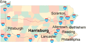 Click on the highway map thumbnail
to view a scalable Pennsylvania road map. |
PA Topo Map Click map to enlarge.
|
PA Relief Map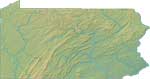 Click map to enlarge.
|
The detailed Pennsylvania map and the regional Pennsylvania map display cities, roads, rivers, and lakes as well as terrain features. The detailed map shows only the Commonwealth of Pennsylvania, while the regional map shows Pennsylvania and the surrounding region.
Pennsylvania Infrastructure > Pennsylvania Airports
In 2005, the population of Pennsylvania was estimated at 12,405,348, which is about 277.3 people per square mile. In 2010, Pennsylvania's population rose to 12,702,379 people. More recently, in the 2020 census, the Pennsylvania population was 13,002,700. The state's primary Interstate Highways include I-70, I-76, I-78, and I-79 as well as I-80, I-81, and I-84.
Pennsylvania Topography and Historic Sites
Pennsylvania signifies "Penn's woodlands" and was named for Admiral Sir William Penn, father of Quaker colonist and founder William Penn. Apart from small low-lying areas in the northwest and southeast, Much of Pennsylvania's terrain is composed of mountain ridges and rolling hills, interspersed with narrow valleys. Along Lake Erie in the northwest and along the Delaware River in the southeast, the terrain is lower and fairly level. The Delaware River, Pennsylvania's eastern border, flows near Philadelphia, while the Susquehanna and Allegheny Rivers flow through central and western Pennsylvania, respectively. Tourists come to see the state's many historic sites such as Gettysburg National Military Park and Valley Forge National Historic Park, as well as Independence National Park in Philadelphia. Visit the official Pennsylvania tourism site and Pennsylvania Atlas for Pennsylvania travel and tourism information.
Other Maps of Pennsylvania
This Pennsylvania reference map shows major cities, roads, railroads, and physical features in Pennsylvania.Several map publishing companies offer printed maps of Pennsylvania. For example, Omni Resources offers several maps of Pennsylvania that feature points of interest, airports, and parks, as well as selected local attractions and insets of major Pennsylvania cities.
All rights reserved.
Certain maps hereon are © Map Resources or Digital Wisdom.
To facilitate browsing, certain external links will open in new windows.
Pennsylvania-Map.org Editor, State Maps, PO Box 828, Barnegat, NJ 08005.